File:Constanta-Rotterdam DE.PNG
Jump to navigation
Jump to search
Size of this preview: 800 × 337 pixels. Other resolutions: 320 × 135 pixels | 894 × 377 pixels.
Original file (894 × 377 pixels, file size: 32 KB, MIME type: image/png)
Captions
Captions
Add a one-line explanation of what this file represents
Summary
[edit]
| Description |
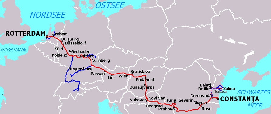
Deutsch: Die Schifffahrtsroute Rotterdam-Constanţa ist die kürzeste schiffbare Verbindung zwischen der Nordsee und dem Schwarzen Meer über den Rhein, Main, Main-Donau-Kanal, die Donau und den Donau-Schwarzmeer-Kanal. |
| Date | |
| Source | Own work |
| Author | Olahus |
| Other versions | File:Constanta-Rotterdam eo.png (auf Esperanto), File:Constanta-Rotterdam blank.png (Karte ohne Meeresnamen), File:Constanta-Rotterdam blank.svg |

|
This transport map image could be re-created using vector graphics as an SVG file. This has several advantages; see Commons:Media for cleanup for more information. If an SVG form of this image is available, please upload it and afterwards replace this template with
{{vector version available|new image name}}.
It is recommended to name the SVG file “Constanta-Rotterdam DE.svg”—then the template Vector version available (or Vva) does not need the new image name parameter. |
Licensing
[edit]
| I, the copyright holder of this work, release this work into the public domain. This applies worldwide. In some countries this may not be legally possible; if so: I grant anyone the right to use this work for any purpose, without any conditions, unless such conditions are required by law. |
Olahus, the copyright holder of this work, hereby publishes it under the following license:
This file is licensed under the Creative Commons Attribution-Share Alike 3.0 Germany license.
Attribution: Olahus
- You are free:
- to share – to copy, distribute and transmit the work
- to remix – to adapt the work
- Under the following conditions:
- attribution – You must give appropriate credit, provide a link to the license, and indicate if changes were made. You may do so in any reasonable manner, but not in any way that suggests the licensor endorses you or your use.
- share alike – If you remix, transform, or build upon the material, you must distribute your contributions under the same or compatible license as the original.

Upload log of prior de:Datei:Constanta-Rotterdam DE.PNG:
- 2008-10-05 16:56:17, 894×377 (32 KB), de:User:Olahus, ({{Information |Beschreibung = Die Schiffahrtsroute Constanţa-Rotterdam ist die kürzeste schiffbare Verbindung zwischen der Nordsee und dem Schwarzen Meer über dem Rhein, Main, Main-Donau-Kanal, die Donau u)
File history
Click on a date/time to view the file as it appeared at that time.
| Date/Time | Thumbnail | Dimensions | User | Comment | |
|---|---|---|---|---|---|
| current | 16:31, 3 June 2009 | | 894 × 377 (32 KB) | Olahus (talk | contribs) | {{Information |Description={{de|1=Die Schiffahrtsroute Rotterdam-Constanţa ist die kürzeste schiffbare Verbindung zwischen der Nordsee und dem Schwarzen Meer über dem [[:de:Rhe |
You cannot overwrite this file.
File usage on Commons
The following 4 pages use this file:
File usage on other wikis
The following other wikis use this file:
- Usage on als.wikipedia.org
- Usage on cs.wikipedia.org
- Usage on da.wikipedia.org
- Usage on de.wikipedia.org
- Usage on fr.wikipedia.org
- Usage on ro.wikipedia.org
- Usage on ru.wikipedia.org
- Usage on sl.wikipedia.org
- Usage on uk.wikipedia.org