File:Dayton.png
Jump to navigation
Jump to search

Size of this preview: 619 × 599 pixels. Other resolutions: 248 × 240 pixels | 496 × 480 pixels | 793 × 768 pixels | 1,057 × 1,024 pixels | 1,809 × 1,752 pixels.
Original file (1,809 × 1,752 pixels, file size: 171 KB, MIME type: image/png)
Captions
Captions
Add a one-line explanation of what this file represents
Summary
[edit]
| Description |
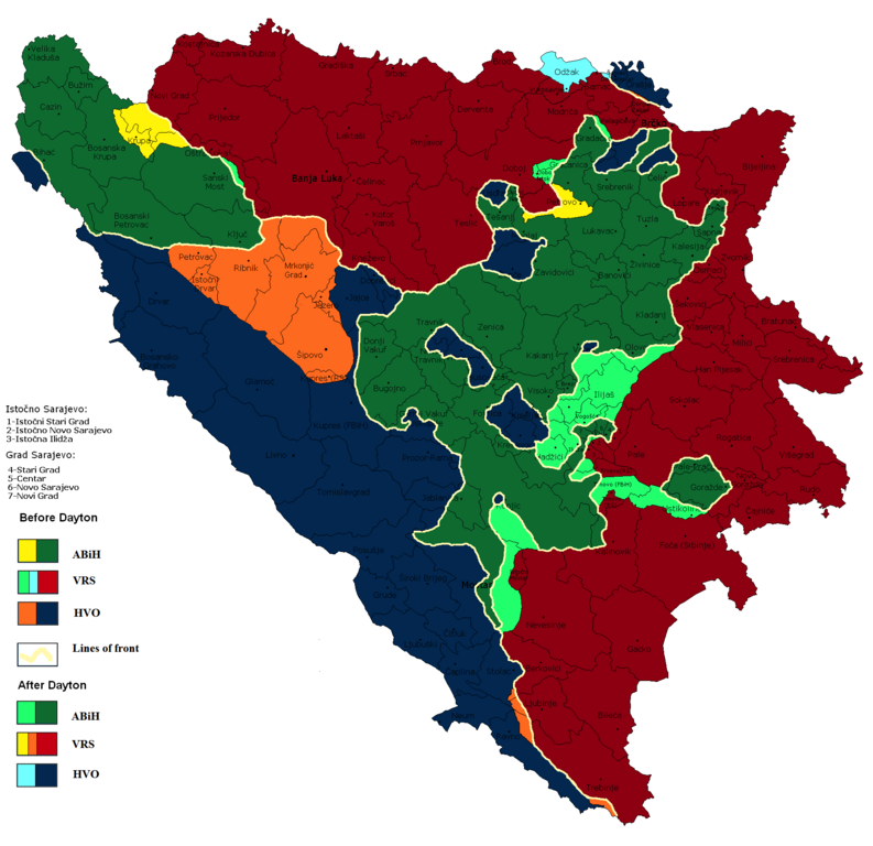
English: Territorial changes as a result of the Dayton Peace Agreement.
Hrvatski: Daytonski mirovni sporazum
Српски / srpski: Дејтонски мировни споразум
Русский: Дейтонский мирный договор |
| Date | |
| Source | File:BeforeDayton.png |
| Author | Ceha |
Licensing
[edit]
| I, the copyright holder of this work, release this work into the public domain. This applies worldwide. In some countries this may not be legally possible; if so: I grant anyone the right to use this work for any purpose, without any conditions, unless such conditions are required by law. |
File history
Click on a date/time to view the file as it appeared at that time.
| Date/Time | Thumbnail | Dimensions | User | Comment | |
|---|---|---|---|---|---|
| current | 12:53, 13 February 2022 | | 1,809 × 1,752 (171 KB) | Ceha (talk | contribs) | Brčko |
| 23:36, 24 January 2022 |  | 1,809 × 1,752 (171 KB) | Ceha (talk | contribs) | Žepče | |
| 23:25, 24 January 2022 |  | 1,809 × 1,752 (171 KB) | Ceha (talk | contribs) | Jugoistočno Brčko | |
| 15:01, 23 January 2022 |  | 1,809 × 1,752 (171 KB) | Ceha (talk | contribs) | Oko Bihaća | |
| 14:56, 23 January 2022 |  | 1,809 × 1,752 (171 KB) | Ceha (talk | contribs) | Oko Bihaća | |
| 14:51, 23 January 2022 |  | 1,809 × 1,752 (171 KB) | Ceha (talk | contribs) | Bihać | |
| 11:42, 18 March 2021 |  | 1,809 × 1,752 (171 KB) | Ceha (talk | contribs) | Mostar | |
| 15:25, 16 March 2021 |  | 1,809 × 1,752 (171 KB) | Ceha (talk | contribs) | Drežnice | |
| 14:23, 19 May 2017 |  | 1,809 × 1,752 (171 KB) | Ceha (talk | contribs) | Rama | |
| 14:18, 19 May 2017 |  | 1,809 × 1,752 (171 KB) | Ceha (talk | contribs) | Uskoplje |
You cannot overwrite this file.
File usage on Commons
The following 10 pages use this file:
- Atlas of Bosnia and Herzegovina
- Atlas of Republika Srpska
- User:J budissin/Uploads/BiH/2017 May 11-20
- User:Magog the Ogre/Maps of conflicts/2015 June
- User:Magog the Ogre/Maps of conflicts/2015 September
- User:Magog the Ogre/Maps of conflicts/2016 December
- User:Magog the Ogre/Maps of conflicts/2017 May
- User:Magog the Ogre/Maps of conflicts/2021 March
- User:Magog the Ogre/Maps of conflicts/2022 February
- User:Magog the Ogre/Maps of conflicts/2022 January
File usage on other wikis
The following other wikis use this file:
- Usage on ar.wikipedia.org
- Usage on ca.wikipedia.org
- Usage on da.wikipedia.org
- Usage on en.wikipedia.org
- Usage on es.wikipedia.org
- Usage on et.wikipedia.org
- Usage on hr.wikipedia.org
- Usage on ka.wikipedia.org
- Usage on mk.wikipedia.org
- Usage on ms.wikipedia.org
- Usage on ru.wikipedia.org
- Usage on sh.wikipedia.org
- Usage on sr.wikipedia.org
- Usage on tr.wikipedia.org
- Usage on www.wikidata.org
Metadata
Categories:
- Maps of the history of Bosnia and Herzegovina in modern times
- Maps of the history of the Federation of Bosnia and Herzegovina
- Maps of the history of Republika Srpska
- Maps of the peace plans of the Bosnian war
- Maps of Republika Srpska (1992-1995)
- Maps of the Croatian Republic of Herzeg-Bosnia
- Maps of the Yugoslav wars