File:Deutschesreich1939.png
Jump to navigation
Jump to search

Size of this preview: 764 × 600 pixels. Other resolutions: 306 × 240 pixels | 612 × 480 pixels | 979 × 768 pixels | 1,032 × 810 pixels.
Original file (1,032 × 810 pixels, file size: 262 KB, MIME type: image/png)
Captions
Captions
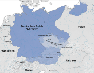
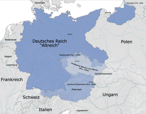
Germany's (Altreich) borders as of 31 December 1937, and subsequent expansion before WWII.
| Description |
Deutsch: Die Grenzen des Deutschen Reiches (Altreich) am 31. 12. 1937 und Ausdehnungen 1938/1939 |
||
| Source | Own work and Demis | ||
| Author | FJ-de | ||
| Permission (Reusing this file) |
|
||
| Other versions |
.png)

|
This historical map image could be re-created using vector graphics as an SVG file. This has several advantages; see Commons:Media for cleanup for more information. If an SVG form of this image is available, please upload it and afterwards replace this template with
{{vector version available|new image name}}.
It is recommended to name the SVG file “Deutschesreich1939.svg”—then the template Vector version available (or Vva) does not need the new image name parameter. |
File history
Click on a date/time to view the file as it appeared at that time.
| Date/Time | Thumbnail | Dimensions | User | Comment | |
|---|---|---|---|---|---|
| current | 11:40, 3 October 2009 | | 1,032 × 810 (262 KB) | NordNordWest (talk | contribs) | |
| 10:12, 29 September 2009 |  | 1,032 × 810 (262 KB) | NordNordWest (talk | contribs) | ||
| 18:47, 11 January 2009 |  | 1,032 × 810 (259 KB) | NordNordWest (talk | contribs) | + Danzig | |
| 17:19, 18 November 2008 |  | 1,032 × 810 (259 KB) | NordNordWest (talk | contribs) | some corrections | |
| 16:10, 28 November 2005 |  | 1,032 × 810 (287 KB) | FJ-de (talk | contribs) | Karte ist erstellt von mir - Vorlage Demis http://www.demis.nl/wms/mapclip.htm |
You cannot overwrite this file.
File usage on Commons
The following 7 pages use this file:
File usage on other wikis
The following other wikis use this file:
- Usage on af.wikipedia.org
- Usage on azb.wikipedia.org
- Usage on be.wikipedia.org
- Usage on ca.wikipedia.org
- Usage on cs.wikipedia.org
- Usage on da.wikipedia.org
- Usage on de.wikipedia.org
- Usage on en.wikipedia.org
- Usage on eo.wikipedia.org
- Usage on es.wikipedia.org
- Usage on et.wikipedia.org
- Usage on fi.wikipedia.org
- Usage on fi.wikibooks.org
- Usage on fr.wikipedia.org
- Usage on hu.wikipedia.org
- Usage on it.wikipedia.org
- Usage on lb.wikipedia.org
- Usage on nov.wikipedia.org
- Usage on no.wikipedia.org
- Usage on pl.wikipedia.org
- Usage on ro.wikipedia.org
- Usage on ru.wikipedia.org
- Usage on sh.wikipedia.org
- Usage on simple.wikipedia.org
- Usage on sk.wikipedia.org
- Usage on sv.wikipedia.org
- Usage on zh.wikipedia.org