File:Distribution map of Hynobius kimurae, H. boulengeri & H. fossigenus.png
Jump to navigation
Jump to search

Size of this preview: 800 × 506 pixels. Other resolutions: 320 × 202 pixels | 640 × 405 pixels | 1,024 × 648 pixels | 1,280 × 809 pixels | 2,437 × 1,541 pixels.
Original file (2,437 × 1,541 pixels, file size: 1.13 MB, MIME type: image/png)
Captions
Captions
Add a one-line explanation of what this file represents
| Description |
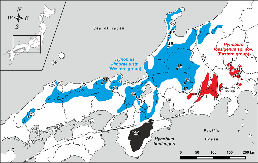
English: Map of central and western parts of Honshu Island, Japan, showing sampling localities of Hynobius kimurae sensu lato (closed circles: 1–23) and H. boulengeri (closed circle: 24).
Blue and red areas indicate known distribution range of H. kimurae sensu lato (Western and Eastern groups, respectively), the black area corresponds to the known distribution range of H. boulengeri. A dot in a center of a circle denotes the type locality. Study sites: ISTL, Itoigawa-Shizuoka Tectonic Line; JMTL, Japanese Median Tectonic Line. |
| Date | |
| Source | https://peerj.com/articles/5084/#fig-1 |
| Author | Hisanori Okamiya, Hirotaka Sugawara, Masahiro Nagano, Nikolay A. Poyarkov |
| Permission (Reusing this file) |
This file is licensed under the Creative Commons Attribution-Share Alike 4.0 International license.
|
File history
Click on a date/time to view the file as it appeared at that time.
| Date/Time | Thumbnail | Dimensions | User | Comment | |
|---|---|---|---|---|---|
| current | 19:27, 8 July 2018 | | 2,437 × 1,541 (1.13 MB) | Mr. Fulano (talk | contribs) | Transferred from https://dfzljdn9uc3pi.cloudfront.net/2018/5084/1/fig-1-full.png |
You cannot overwrite this file.
File usage on Commons
The following 2 pages use this file:
File usage on other wikis
The following other wikis use this file:
- Usage on de.wikipedia.org
- Usage on en.wikipedia.org
- Usage on eu.wikipedia.org
- Usage on pt.wikipedia.org
- Usage on sv.wikipedia.org
- Usage on www.wikidata.org