File:Dokdo Map.png
Jump to navigation
Jump to search
Size of this preview: 657 × 600 pixels. Other resolutions: 263 × 240 pixels | 526 × 480 pixels | 748 × 683 pixels.
Original file (748 × 683 pixels, file size: 9 KB, MIME type: image/png)
Captions
Captions
Add a one-line explanation of what this file represents
Transferred from en.wikipedia to Commons by Maksim.
The original description page was here. All following user names refer to en.wikipedia.
Summary
[edit]
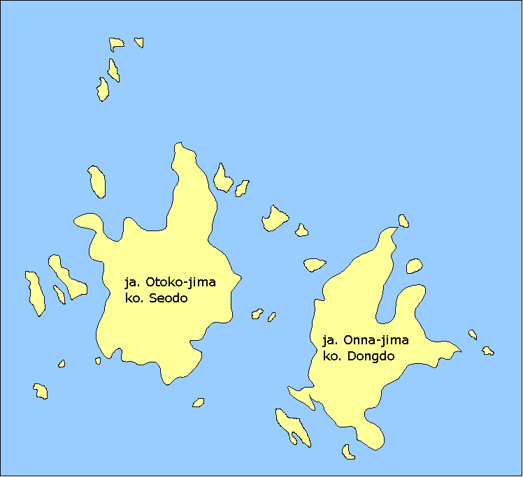
- Description: Map of the Liancourt Rocks (disputed land between South Korea and Japan) showing the two main islets and some of the minor ones.
- Source: Drawn myself.
Licensing
[edit]
I, the copyright holder of this work, hereby publish it under the following licenses:

|
Permission is granted to copy, distribute and/or modify this document under the terms of the GNU Free Documentation License, Version 1.2 or any later version published by the Free Software Foundation; with no Invariant Sections, no Front-Cover Texts, and no Back-Cover Texts. A copy of the license is included in the section entitled GNU Free Documentation License. |
| This file is licensed under the Creative Commons Attribution-Share Alike 3.0 Unported license. | ||
| ||
| This licensing tag was added to this file as part of the GFDL licensing update. |
You may select the license of your choice.
| date/time | username | edit summary |
|---|---|---|
| 11:10, 9 January 2006 | en:User:Kokiri | (*Description: Map of the <a href="/wiki/Liancourt_Rocks" title="Liancourt Rocks">Liancourt Rocks</a>, showing the two main islets and some of the minor ones. *Source: Drawn myself.) |
| 2006-07-23 (en WP) 2006-07-30 12:13 (Commons) |
en:User:Bkell (User:Bkell) |
removed "Wikipedia" in lower right-hand corner, reduced color depth to 16 colors |
Original upload log
[edit]
Legend: (cur) = this is the current file, (del) = delete this old version, (rev) = revert to this old version.
Click on date to download the file or see the image uploaded on that date.
- (del) (cur) 11:10, 9 January 2006 . . en:User:Kokiri Kokiri ( en:User_talk:Kokiri Talk) . . 748x683 (80856 bytes) (*Description: Map of the en:Liancourt_Rocks Liancourt Rocks, showing the two main islets and some of the minor ones. *Source: Drawn myself.)
derivative works
[edit]
Derivative works of this file: Liancourt Rocks Map.png
File history
Click on a date/time to view the file as it appeared at that time.
| Date/Time | Thumbnail | Dimensions | User | Comment | |
|---|---|---|---|---|---|
| current | 01:34, 26 June 2009 | | 748 × 683 (9 KB) | Valentim (talk | contribs) | See File talk and en:Wikipedia:Village_pump_(miscellaneous)#Jp..2FKr._vs._Jap..2FKor._in_commons:File_talk:Dokdo_Map.png |
| 16:36, 21 June 2009 |  | 748 × 683 (9 KB) | Valentim (talk | contribs) | Reverted to version as of 13:22, 21 June 2009. I did!! Have a look on the discussion page!! | |
| 15:06, 21 June 2009 |  | 748 × 683 (8 KB) | Forestfarmer (talk | contribs) | put en:ISO 3166-1 alpha-3 into this map. If anyone argue about this map. do not revert and talk with me! | |
| 13:22, 21 June 2009 |  | 748 × 683 (9 KB) | Valentim (talk | contribs) | Reverted : w:en:ISO 3166-1 alpha-2 defines codes for the *names* of countries, but is not the abbreviations for an *adjektive of an language*. (See also w:en:ISO 3166-1, w:en:ISO 3166.) For the abbreviations see my last comment. Don't get conf | |
| 20:33, 19 June 2009 |  | 748 × 683 (8 KB) | Forestfarmer (talk | contribs) | Reverted to version as of 16:47, 15 June 2009 Sorry but see ISO 3166-1 alpha-2 and Jap is irrelevant. | |
| 17:41, 18 June 2009 |  | 748 × 683 (9 KB) | Valentim (talk | contribs) | Reverted to version as of 15:04, 22 February 2009. Jp./Kr. are no ordinary or extrem unpopulary abbreviations, see [http://www.abbreviations.com/bs.aspx?st=japanese&SE=2], [http://www.abbreviations.com/bs.aspx?st=korean&SE=2]. | |
| 16:47, 15 June 2009 |  | 748 × 683 (8 KB) | Forestfarmer (talk | contribs) | I changed Country code,Jap to ja and Kor to Kr and font to Times New Roman Bold. | |
| 15:04, 22 February 2009 |  | 748 × 683 (9 KB) | Valentim (talk | contribs) | Reverted to version as of 19:48, 26 January 2009. Picture is used on several wikis with NPOV-rule. Therefore, naming have to be from both countries. | |
| 23:25, 21 February 2009 |  | 748 × 683 (9 KB) | Ksiom (talk | contribs) | Reverted to version as of 12:13, 30 July 2006 | |
| 19:48, 26 January 2009 |  | 748 × 683 (9 KB) | Valentim (talk | contribs) | {{Information |Description=Liancourt Rocks |Source=own work |Date=26.01.2009 |Author=Valentim |Permission=free |other_versions=Image:Dokdo_Map.png }} Removed translated names and added both native names (japanese and korean). |
#Jp..2FKr._vs._Jap..2FKor._in_commons:File_talk:Dokdo_Map.png)
You cannot overwrite this file.
File usage on Commons
The following 5 pages use this file:
File usage on other wikis
The following other wikis use this file:
- Usage on en.wikipedia.org
- Usage on nl.wikipedia.org
- Usage on sv.wikipedia.org