File:IRP.PNG
Jump to navigation
Jump to search

Size of this preview: 763 × 600 pixels. Other resolutions: 305 × 240 pixels | 611 × 480 pixels | 977 × 768 pixels | 1,280 × 1,006 pixels | 1,992 × 1,566 pixels.
Original file (1,992 × 1,566 pixels, file size: 922 KB, MIME type: image/png)
Captions
Captions
Add a one-line explanation of what this file represents

|
This historical map image could be re-created using vector graphics as an SVG file. This has several advantages; see Commons:Media for cleanup for more information. If an SVG form of this image is available, please upload it and afterwards replace this template with
{{vector version available|new image name}}.
It is recommended to name the SVG file “IRP.svg”—then the template Vector version available (or Vva) does not need the new image name parameter. |
Summary
[edit]
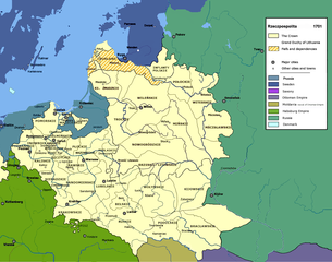
Polish-Lithuanian Commonwealth in 1701 author: User:Mathiasrex, Maciej Szczepańczyk based on layers of :user:Halibutt
Licensing
[edit]
I, the copyright holder of this work, hereby publish it under the following licenses:

|
Permission is granted to copy, distribute and/or modify this document under the terms of the GNU Free Documentation License, Version 1.2 or any later version published by the Free Software Foundation; with no Invariant Sections, no Front-Cover Texts, and no Back-Cover Texts. A copy of the license is included in the section entitled GNU Free Documentation License. |
| This file is licensed under the Creative Commons Attribution-Share Alike 3.0 Unported license. | ||
| ||
| This licensing tag was added to this file as part of the GFDL licensing update. |
This file is licensed under the Creative Commons Attribution-Share Alike 2.5 Generic, 2.0 Generic and 1.0 Generic license.
- You are free:
- to share – to copy, distribute and transmit the work
- to remix – to adapt the work
- Under the following conditions:
- attribution – You must give appropriate credit, provide a link to the license, and indicate if changes were made. You may do so in any reasonable manner, but not in any way that suggests the licensor endorses you or your use.
- share alike – If you remix, transform, or build upon the material, you must distribute your contributions under the same or compatible license as the original.
You may select the license of your choice.
File history
Click on a date/time to view the file as it appeared at that time.
| Date/Time | Thumbnail | Dimensions | User | Comment | |
|---|---|---|---|---|---|
| current | 18:29, 13 April 2020 | | 1,992 × 1,566 (922 KB) | Claude Zygiel (talk | contribs) | Some details since Stier, H.E. (ed.) ''Grosser Atlas zur Weltgeschichte'', Westermann 1985, {{ISBN|3-14-100919-8}}, ''Putzger historischer Weltatlas'', Cornelsen 1990, {{ISBN|3-464-00176-8}}, Sellier, A.J. (ed.) « Atlas des Peuples » -''Europe centrale'', 1992, {{ISBN|2-7071-2032-4}} La Découverte publ., {{ISBN|2-7071-2222-X}}, Unger, M. (ed.) ''Történelmi atlasz'', Hungarian academy 1991, {{ISBN|963-351-422-3}}. |
| 18:56, 12 January 2012 |  | 1,992 × 1,566 (924 KB) | Mathiasrex (talk | contribs) | new version | |
| 17:24, 12 January 2012 |  | 1,992 × 1,566 (924 KB) | Mathiasrex (talk | contribs) | new version | |
| 18:22, 27 November 2011 |  | 2,000 × 1,568 (1,007 KB) | Mathiasrex (talk | contribs) | new version | |
| 18:22, 27 November 2011 |  | 2,000 × 1,568 (1,007 KB) | Mathiasrex (talk | contribs) | new version | |
| 12:14, 26 February 2008 |  | 2,000 × 1,568 (1.04 MB) | Mathiasrex (talk | contribs) | {{Information |Description= |Source= |Date= |Author= |Permission= |other_versions= }} | |
| 11:48, 30 November 2007 |  | 2,000 × 1,568 (900 KB) | Mathiasrex (talk | contribs) | ||
| 08:30, 16 July 2006 |  | 2,000 × 1,568 (1,011 KB) | Mathiasrex (talk | contribs) | Polish-Lithuanian Commonwealth in 1701 authors:user:Halibutt and user:Mathiasrex Category:Polish history |
You cannot overwrite this file.
File usage on Commons
The following 4 pages use this file:
File usage on other wikis
The following other wikis use this file:
- Usage on be-tarask.wikipedia.org
- Usage on be.wikipedia.org
- Usage on en.wikipedia.org
- Usage on es.wikipedia.org
- Usage on et.wikipedia.org
- Usage on fr.wikipedia.org
- Usage on hu.wikipedia.org
- Usage on hy.wikipedia.org
- Usage on ja.wikipedia.org
- Usage on lt.wikipedia.org
- Usage on pl.wikipedia.org
- Usage on ro.wikipedia.org
- Usage on ru.wikipedia.org
- Usage on sl.wikipedia.org
- Usage on tr.wikipedia.org
- Usage on uk.wikipedia.org