File:Kis-vlachföldek.png

Original file (1,758 × 1,308 pixels, file size: 1.49 MB, MIME type: image/png)
Captions
Captions

Summary
[edit]
| Description |
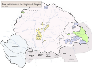
English: Map of Hungary at the end of the 13th century, based on the other version but showing also the Oláh (Vlach) areas under Vlach Jog in versions not aligned with the current Hungarian point of view. Français : Carte de la Hongrie à la fin du XIIIe siècle, basée sur l'autre version mais figurant aussi, dans les versions non-alignées sur le point de vue hongrois, les zones roumanophones sous Vlach Jog ("droit valaque"). |
| Date | |
| Source |
May 20, 2022, february 16 and june 8, 2024 hungarian versions (according to hungarian contributors, only this sources are serious, academic and reliable): Béla Köpeczi (dir.), Erdély rövid története ("Abridged History of Transylvania"), Akadémiai Kiadó, Budapest 1989, ISBN 9630559013 following Eduard Robert Rössler, Romänische Studien: untersuchungen zur älteren Geschichte Rumäniens ("New Studies: Investigations into the Ancient History of Romania"), Leipzig, 1871.
|
| Author | Julieta39, modified by OrionNimrod following the hungarian point of view (current version) |
| Permission (Reusing this file) |
Own work |
| Other versions | File:Hungary 13th cent.png, already into line with the Hungarian point of view; this version here was created to show the other point of view, in accordance with the latin expression: «Audi alteram partem»: see discussion file. |
Licensing
[edit]
- You are free:
- to share – to copy, distribute and transmit the work
- to remix – to adapt the work
- Under the following conditions:
- attribution – You must give appropriate credit, provide a link to the license, and indicate if changes were made. You may do so in any reasonable manner, but not in any way that suggests the licensor endorses you or your use.
- share alike – If you remix, transform, or build upon the material, you must distribute your contributions under the same or compatible license as the original.
File history
Click on a date/time to view the file as it appeared at that time.
| Date/Time | Thumbnail | Dimensions | User | Comment | |
|---|---|---|---|---|---|
| current | 14:00, 8 June 2024 | | 1,758 × 1,308 (1.49 MB) | OrionNimrod (talk | contribs) | That is the academic Hungarian source map: No Vlach borders inside Hungary, that is only a Photoshopped fantasy by Romanian nationalists, not nice to falsify maps: https://djnaploja.wordpress.com/wp-content/uploads/2015/11/magyar-kirc3a1lysc3a1g-xiii-sz.jpg |
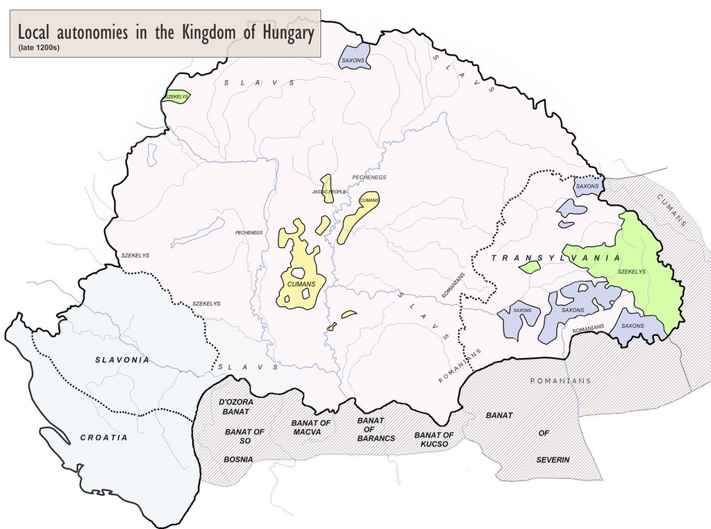
| 23:04, 17 February 2024 |  | 835 × 626 (567 KB) | WajWohu (talk | contribs) | Reverted to version as of 20:41, 1 July 2022 (UTC) Please discuss that revert on discussion page, where's a consensus and view scientific sources of: File:Magyarország XII-XIII század második felében.jpg (nearby the same borders) | |
| 19:57, 16 February 2024 |  | 1,758 × 1,308 (1.49 MB) | OrionNimrod (talk | contribs) | Restore original: Vlach law existed. but it did not have borders, what is the academic source of that borders of Vlach law? That is just Photoshopped by user | |
| 20:41, 1 July 2022 |  | 835 × 626 (567 KB) | Enlightenment1685 (talk | contribs) | I restored the Romanian version | |
| 00:53, 1 July 2022 |  | 1,758 × 1,308 (1.49 MB) | Enlightenment1685 (talk | contribs) | I restoren the original version | |
| 13:10, 25 June 2022 |  | 834 × 625 (455 KB) | Trecătorul răcit (talk | contribs) | Sorry but the nationalist hungarian pov which denies the existence of Vlach Jog is not "neutral". | |
| 00:19, 4 June 2022 |  | 1,757 × 1,307 (1.25 MB) | Enlightenment1685 (talk | contribs) | The original neutral version of the map. | |
| 10:31, 20 May 2022 |  | 834 × 625 (455 KB) | Trecătorul răcit (talk | contribs) | Közös jog & details according with Történelmi atlasz, Akademiai kiado, Budapest 1991, ISBN 963-351-422-3 | |
| 19:10, 13 May 2022 |  | 834 × 625 (446 KB) | Trecătorul răcit (talk | contribs) | Added Iasses & Pechenegs | |
| 18:50, 13 May 2022 |  | 834 × 625 (446 KB) | Trecătorul răcit (talk | contribs) | Better legend |
You cannot overwrite this file.
File usage on Commons
There are no pages that use this file.
File usage on other wikis
The following other wikis use this file:
- Usage on de.wikipedia.org