File:Maka-Njem ethnic groups.png
Jump to navigation
Jump to search
Size of this preview: 800 × 396 pixels. Other resolutions: 320 × 158 pixels | 640 × 317 pixels | 1,000 × 495 pixels.
Original file (1,000 × 495 pixels, file size: 271 KB, MIME type: image/png)
Captions
Captions
Add a one-line explanation of what this file represents
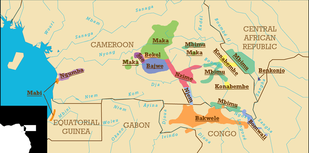
Map showing the location of the various ethnic groups who speak Maka-Njem languages.
Created in Adobe Illustrator 10.03 and Adobe Photoshop 7 using as base a computer-generated map from Map-It: Form-based Simple Map Generator archive copy at the Wayback Machine
References
[edit]
- Austen, Ralph A. and Derrick, Jonathan (1999): Middlemen of the Cameroons Rivers: The Duala and their Hinterland, c. 1600—c.1960. Cambridge University Press.
- Fanso, V.G. (1989): Cameroon History for Secondary Schools and Colleges, Vol. 1: From Prehistoric Times to the Nineteenth Century. Hong Kong: Macmillan Education Ltd.
- Gordon, Raymond G., Jr. (ed.) (2005): Ethnologue: Languages of the World, 15th ed. Dallas: SIL International. Online version accessed 29 August 2005.

|
Permission is granted to copy, distribute and/or modify this document under the terms of the GNU Free Documentation License, Version 1.2 or any later version published by the Free Software Foundation; with no Invariant Sections, no Front-Cover Texts, and no Back-Cover Texts. A copy of the license is included in the section entitled GNU Free Documentation License. |
| This file is licensed under the Creative Commons Attribution-Share Alike 3.0 Unported license. | ||
| ||
| This licensing tag was added to this file as part of the GFDL licensing update. |
This file is licensed under the Creative Commons Attribution-Share Alike 2.5 Generic license.
- You are free:
- to share – to copy, distribute and transmit the work
- to remix – to adapt the work
- Under the following conditions:
- attribution – You must give appropriate credit, provide a link to the license, and indicate if changes were made. You may do so in any reasonable manner, but not in any way that suggests the licensor endorses you or your use.
- share alike – If you remix, transform, or build upon the material, you must distribute your contributions under the same or compatible license as the original.
File history
Click on a date/time to view the file as it appeared at that time.
| Date/Time | Thumbnail | Dimensions | User | Comment | |
|---|---|---|---|---|---|
| current | 00:30, 1 September 2005 | | 1,000 × 495 (271 KB) | Amcaja (talk | contribs) | Various visual improvements. |
| 00:49, 30 August 2005 |  | 1,000 × 493 (305 KB) | Amcaja (talk | contribs) | Map showing the location of the various Maka-Njem ethnic groups of Cameroon. Created in Adobe Illustrator 10.03 and Adobe Photoshop 7 using as base a computer-generated map from [http://stellwagen.er.usgs.gov/mapit/ Map-It: Form-based Simple Map Generato |
You cannot overwrite this file.
File usage on Commons
The following 6 pages use this file:
File usage on other wikis
The following other wikis use this file:
- Usage on de.wikipedia.org
- Usage on en.wikipedia.org
- Usage on es.wikipedia.org
- Usage on fr.wikipedia.org
- Usage on hr.wikipedia.org
- Usage on ka.wikipedia.org
- Usage on ru.wikipedia.org