File:Map of Mexico 1847.jpg
Jump to navigation
Jump to search
Size of this preview: 800 × 570 pixels. Other resolutions: 320 × 228 pixels | 640 × 456 pixels | 1,024 × 730 pixels | 1,280 × 912 pixels | 2,560 × 1,824 pixels | 3,000 × 2,138 pixels.
Original file (3,000 × 2,138 pixels, file size: 1.87 MB, MIME type: image/jpeg)
Captions
Captions
Add a one-line explanation of what this file represents

|
This map has been uploaded by Electionworld from en.wikipedia.org to enable the |
Summary
[edit]
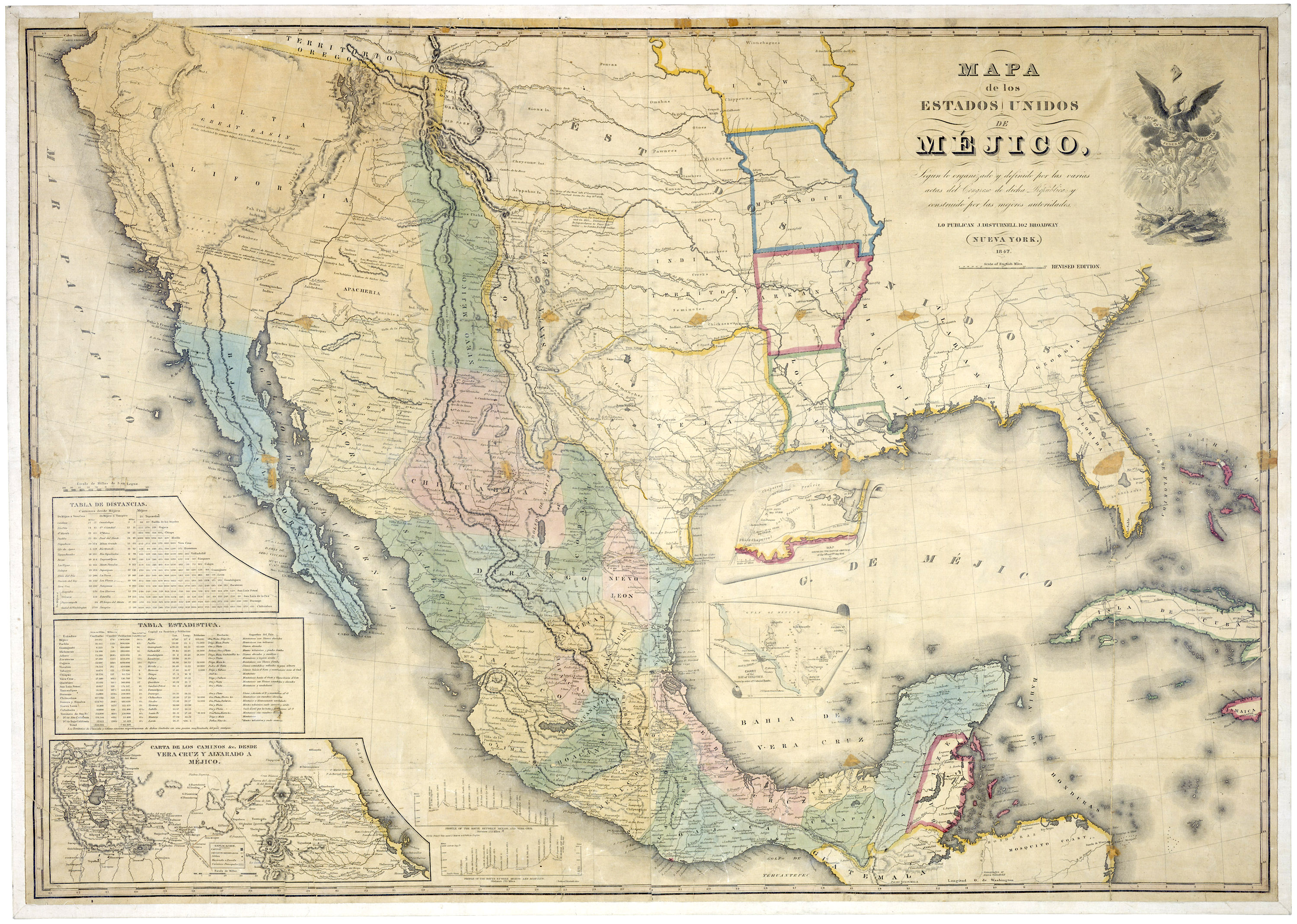
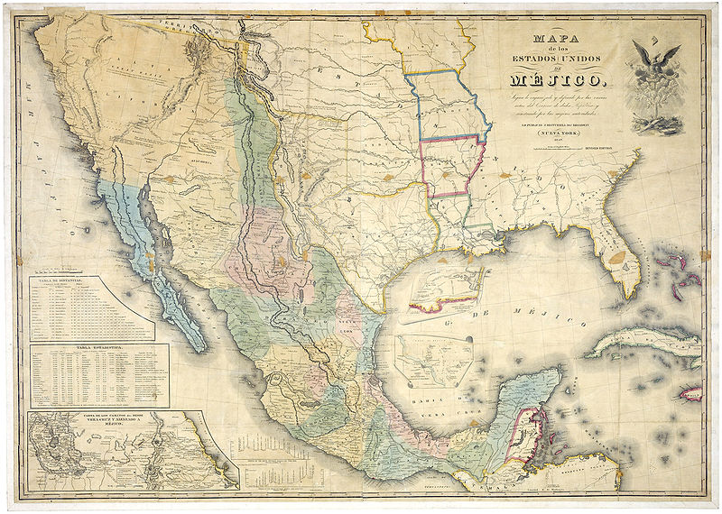
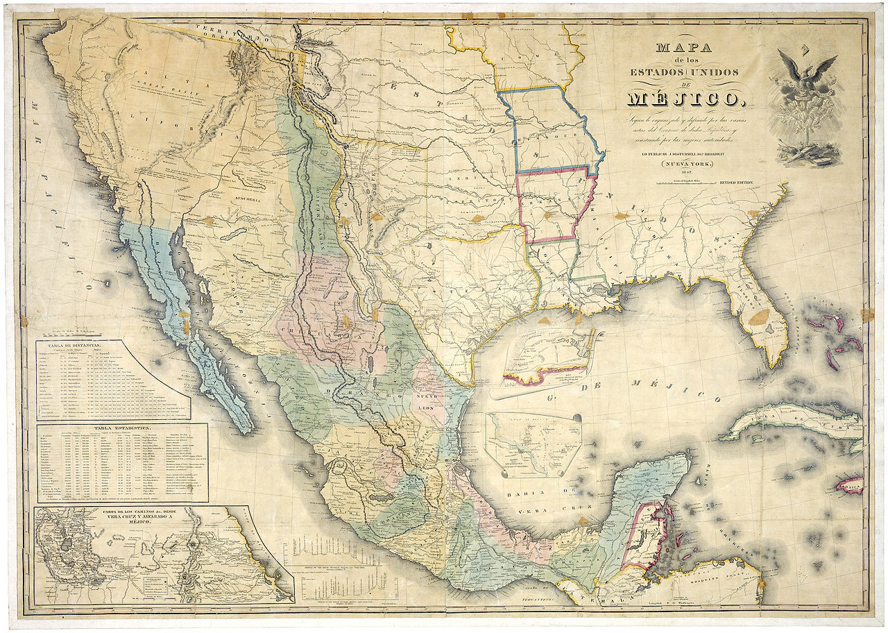
Most claimed territory not settled.
| Description |
English: "Map of the United States of Mexico, according to what has been organized and defined by the various acts of the Congress of said republic, created by the best authorities."
Español: "Mapa de los Estados Unidos de Méjico, según lo organizado y definido por las varias actas del Congreso de dicha República, y construido por las mejores autoridades." |
||||||
| Date | |||||||
| Source | https://www.archives.gov/publications/prologue/2005/summer/images/mexico-disturnell-l.jpg | ||||||
| Author | J. Distrunell, 102 Broadway, New York | ||||||
| Permission (Reusing this file) |
|
Licensing
[edit]
This media file is in the public domain in the United States. This applies to U.S. works where the copyright has expired, often because its first publication occurred prior to January 1, 1929, and if not then due to lack of notice or renewal. See this page for further explanation.
|
 | |
 |
This image might not be in the public domain outside of the United States; this especially applies in the countries and areas that do not apply the rule of the shorter term for US works, such as Canada, Mainland China (not Hong Kong or Macao), Germany, Mexico, and Switzerland. The creator and year of publication are essential information and must be provided. See Wikipedia:Public domain and Wikipedia:Copyrights for more details.
|
This media is available in the holdings of the National Archives and Records Administration, cataloged under the National Archives Identifier (NAID) 1601538.
This tag does not indicate the copyright status of the attached work. A normal copyright tag is still required. See Commons:Licensing.
|
The map gives a publication date of 1847.
File history
Click on a date/time to view the file as it appeared at that time.
| Date/Time | Thumbnail | Dimensions | User | Comment | |
|---|---|---|---|---|---|
| current | 21:18, 16 December 2006 | | 3,000 × 2,138 (1.87 MB) | Electionworld (talk | contribs) | {{ew|en|Gflores}} == Summary == http://www.archives.gov/publications/prologue/2005/summer/images/mexico-disturnell-l.jpg Claimed Territory most not setttled == Licensing == {{PD-USGov}} |
You cannot overwrite this file.
File usage on Commons
The following page uses this file:
File usage on other wikis
The following other wikis use this file:
- Usage on ar.wikipedia.org
- Usage on ca.wikipedia.org
- Usage on de.wikipedia.org
- Usage on en.wikipedia.org
- Usage on eo.wikipedia.org
- Usage on es.wikipedia.org
- Usage on ja.wikipedia.org
- Usage on pt.wikipedia.org
- Usage on ro.wikipedia.org
- Usage on ru.wikipedia.org
- Usage on sv.wikipedia.org
- Usage on uk.wikipedia.org
- Usage on zh.wikipedia.org