File:Quebec province transportation and cities map-fr.jpg
Jump to navigation
Jump to search

Size of this preview: 484 × 600 pixels. Other resolutions: 194 × 240 pixels | 387 × 480 pixels | 620 × 768 pixels | 1,261 × 1,563 pixels.
Original file (1,261 × 1,563 pixels, file size: 618 KB, MIME type: image/jpeg)
Captions
Captions
Add a one-line explanation of what this file represents
Summary
[edit]| Camera location | | View this and other nearby images on: OpenStreetMap |
|---|
| Description |
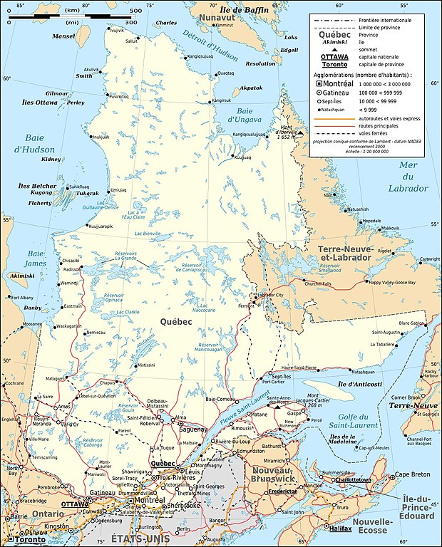
Français : Carte en français du Québec, Canada, avec routes et voies ferrées principales et agglomérations suivant le recensement de 2000.
|
||
| Date | |||
| Source |
Own work ;
|
||
| Author | Eric Gaba (Sting - fr:Sting) | ||
| Permission (Reusing this file) |
|
||
| Other versions |
[]
Same base map but with topography and without transportation:
Same map, but with an extra layer containing locations of Hydro-Québec's generating stations and 735 kV lines and substations
|


Licensing
[edit]
I, the copyright holder of this work, hereby publish it under the following licenses:

|
Permission is granted to copy, distribute and/or modify this document under the terms of the GNU Free Documentation License, Version 1.2 or any later version published by the Free Software Foundation; with no Invariant Sections, no Front-Cover Texts, and no Back-Cover Texts. A copy of the license is included in the section entitled GNU Free Documentation License. |
This file is licensed under the Creative Commons Attribution-Share Alike Attribution-Share Alike 4.0 International, 3.0 Unported, 2.5 Generic, 2.0 Generic and 1.0 Generic license.
- You are free:
- to share – to copy, distribute and transmit the work
- to remix – to adapt the work
- Under the following conditions:
- attribution – You must give appropriate credit, provide a link to the license, and indicate if changes were made. You may do so in any reasonable manner, but not in any way that suggests the licensor endorses you or your use.
- share alike – If you remix, transform, or build upon the material, you must distribute your contributions under the same or compatible license as the original.
You may select the license of your choice.
File history
Click on a date/time to view the file as it appeared at that time.
| Date/Time | Thumbnail | Dimensions | User | Comment | |
|---|---|---|---|---|---|
| current | 13:57, 19 July 2010 | | 1,261 × 1,563 (618 KB) | Sting (talk | contribs) | Color profile |
| 16:24, 5 July 2010 |  | 1,261 × 1,563 (636 KB) | Sting (talk | contribs) | sRGB color profile | |
| 21:53, 1 March 2009 |  | 1,261 × 1,563 (704 KB) | Sting (talk | contribs) | == Summary == {{Location|54|00|00|N|68|30|00|W|scale:10000000}} <br/> {{Information |Description={{en|Map in French of Quebec, Canada, with major roads and railroads and 2000' census cities.}} {{fr|Carte en français du [[:fr |
You cannot overwrite this file.
File usage on Commons
The following 16 pages use this file:
- Atlas of Quebec
- User:Sting/Gallery: Regional maps
- Commons:Files used on the AARoads Wiki/55
- File:Quebec Map with Hydro-Québec infrastructures-en.png
- File:Quebec Map with Hydro-Québec infrastructures-en.svg
- File:Quebec Map with Hydro-Québec infrastructures-fr.png
- File:Quebec Map with Hydro-Québec infrastructures-fr.svg
- File:Quebec province topographic map-blank.svg
- File:Quebec province topographic map-fr.svg
- File:Quebec province topographic map-it.svg
- File:Quebec province topographic map-ru.svg
- File:Quebec province transportation and cities map-fr.jpg
- File:Quebec province transportation and cities map-fr.svg
- File:Sagamie.svg
- File:Vallée de la Matapedia.svg
- Template:Other versions/Quebec province map
File usage on other wikis
The following other wikis use this file:
- Usage on en.wikipedia.org
- Usage on fr.wikipedia.org
- Usage on fr.wikibooks.org
- Usage on ru.wikipedia.org