File:Rojava february2014.png
Jump to navigation
Jump to search

Size of this preview: 800 × 405 pixels. Other resolutions: 320 × 162 pixels | 640 × 324 pixels | 1,124 × 569 pixels.
Original file (1,124 × 569 pixels, file size: 54 KB, MIME type: image/png)
Captions
Captions
Add a one-line explanation of what this file represents
Summary
[edit]
| Description |
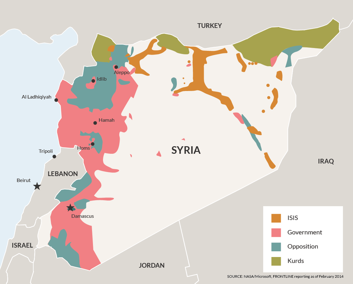
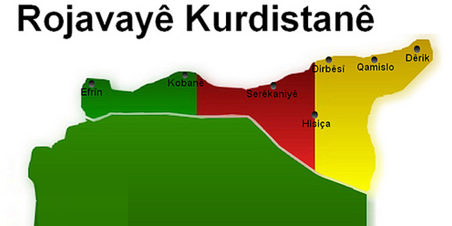
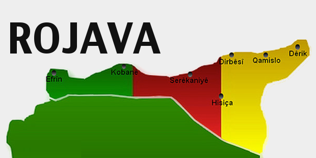
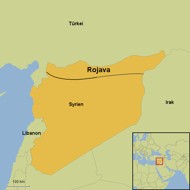
English: Map showing de facto cantons of Rojava (Western Kurdistan) in February 2014, as well as territories claimed by Rojava (Western Kurdistan), but not controlled by the Kurds in February 2014. |
| Date | |
| Source | Own work |
| Author | PANONIAN |
Licensing
[edit]
I, the copyright holder of this work, hereby publish it under the following license:
| This file is made available under the Creative Commons CC0 1.0 Universal Public Domain Dedication. | |
| The person who associated a work with this deed has dedicated the work to the public domain by waiving all of their rights to the work worldwide under copyright law, including all related and neighboring rights, to the extent allowed by law. You can copy, modify, distribute and perform the work, even for commercial purposes, all without asking permission.
|
References
[edit]
Cantons of Rojava (Western Kurdistan) and frontline situation in February 2014:
- http://civiroglu.net/the-constitution-of-the-rojava-cantons/
- http://www.the-american-interest.com/wp-content/uploads/2014/02/syria_battlelines.png
Claimed borders of Rojava (Western Kurdistan):
- http://www.pydrojava.net/en/index.php/kurds-in-west-of-kurdistan/21-list-of-names-of-kurdish-parties-in-west-of-kurdistan
- http://www.pydrojava.net/en/images/west_kurdistan/2013/10/1268440_705746996107027_1388773568_o.jpg
- http://www.pydrojava.net/eng/index.php/kurds-in-west-of-kurdistan/21-list-of-names-of-kurdish-parties-in-west-of-kurdistan archive copy at the Wayback Machine
- http://www.pydrojava.net/eng/images/west_kurdistan/2013/10/1268440_705746996107027_1388773568_o.jpg
- http://freedomroad.org/2014/05/the-revolution-in-rojava/?___p
- http://freedomroad.org/wp-content/uploads/2014/05/kurdistan-map.jpg
- http://www.kurder.dk/nuce/wp-content/uploads/2013/08/rojava.jpg
- http://galeri7.uludagsozluk.com/250/rojava_466585.jpg
- http://rojhelat.info/en/wp-content/uploads/2013/09/rojava-map.png
- http://www.timeturk.com/resim/tr/2013/11/18/rojava-kurdistani-ni-taniyacagiz.jpg
- http://rojhelat.info/en/wp-content/uploads/2013/11/rojava1.jpg
- http://www.kurdistan-post.eu/sites/default/files/styles/large/public/field/image/rojava_21.png?itok=VN8Tg2cO
- http://3.bp.blogspot.com/-or5CLme9lfQ/UJ28cGJsttI/AAAAAAAAAFc/Fb3FZkkz1ek/s1600/5709807449_285d7caef9_b.jpg
- http://www.stepmap.de/landkarte/rojava-1372442.png
File history
Click on a date/time to view the file as it appeared at that time.
| Date/Time | Thumbnail | Dimensions | User | Comment | |
|---|---|---|---|---|---|
| current | 16:40, 30 September 2014 | | 1,124 × 569 (54 KB) | PANONIAN (talk | contribs) | {{Information |Description ={{en|1=Map showing de facto cantons of Western Kurdistan (Rojava) in February 2014, as well as territories claimed by Western Kurdistan (Rojava), but not controlled by the Kurds in February 2014.}} |Source ={{own}... |
You cannot overwrite this file.
File usage on Commons
The following 3 pages use this file:
File usage on other wikis
The following other wikis use this file:
- Usage on ar.wikipedia.org
- Usage on ckb.wikipedia.org
- Usage on cs.wikipedia.org
- Usage on de.wikipedia.org
- Usage on en.wikipedia.org
- Usage on fr.wikipedia.org
- Usage on ku.wikipedia.org
- Usage on pt.wikipedia.org
- Usage on ro.wikipedia.org
- Usage on ru.wikipedia.org
- Usage on sh.wikipedia.org
- Usage on sr.wikipedia.org
- Usage on zh.wikipedia.org