File:Rom1793-1812.png
Jump to navigation
Jump to search
No higher resolution available.
Rom1793-1812.png (587 × 413 pixels, file size: 78 KB, MIME type: image/png)
Captions
Captions
Add a one-line explanation of what this file represents


|
This map image could be re-created using vector graphics as an SVG file. This has several advantages; see Commons:Media for cleanup for more information. If an SVG form of this image is available, please upload it and afterwards replace this template with
{{vector version available|new image name}}.
It is recommended to name the SVG file “Rom1793-1812.svg”—then the template Vector version available (or Vva) does not need the new image name parameter. |
Summary
[edit]
| Description |
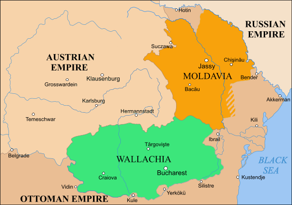
English: Moldavia, Wallachia and Transylvania between the Second Partition of Poland, 1793 and the Treaty of Bucharest, 1812 |
| Source | |
| Author |
Licensing
[edit]
| This file is licensed under the Creative Commons Attribution-Share Alike 3.0 Unported license. Subject to disclaimers. | ||
| ||
| This licensing tag was added to this file as part of the GFDL licensing update. |

|
Permission is granted to copy, distribute and/or modify this document under the terms of the GNU Free Documentation License, Version 1.2 or any later version published by the Free Software Foundation; with no Invariant Sections, no Front-Cover Texts, and no Back-Cover Texts. A copy of the license is included in the section entitled GNU Free Documentation License. Subject to disclaimers. |

|
File:Danubian Principalities 1800.svg is a vector version of this file. It should be used in place of this PNG file when not inferior.
File:Rom1793-1812.png → File:Danubian Principalities 1800.svg
For more information, see Help:SVG. |
 |
File history
Click on a date/time to view the file as it appeared at that time.
| Date/Time | Thumbnail | Dimensions | User | Comment | |
|---|---|---|---|---|---|
| current | 12:49, 8 October 2023 | | 587 × 413 (78 KB) | Gyalu22 (talk | contribs) | Transylvania was part of the Austrian Empire |
| 16:57, 15 February 2019 |  | 587 × 413 (91 KB) | Anonimu (talk | contribs) | Reverted to version as of 10:18, 2 November 2018 (UTC) | |
| 17:13, 13 February 2019 |  | 587 × 413 (106 KB) | Julieta39 (talk | contribs) | Since the maps of this time | |
| 10:18, 2 November 2018 |  | 587 × 413 (91 KB) | Anonimu (talk | contribs) | too much detail distract from subject. also,18th century maps are not generally accurate fo the region | |
| 14:58, 19 October 2018 |  | 587 × 413 (113 KB) | Claude Zygiel (talk | contribs) | More details since 18th century maps | |
| 23:26, 11 July 2018 |  | 587 × 413 (91 KB) | Anonimu (talk | contribs) | more accurate borders | |
| 17:22, 8 November 2015 |  | 588 × 413 (89 KB) | Spiridon Ion Cepleanu (talk | contribs) | Colours | |
| 21:05, 21 February 2010 |  | 588 × 413 (51 KB) | Olahus (talk | contribs) | Corrections on the borders to the Ottoman Empire. | |
| 21:01, 19 May 2006 |  | 588 × 413 (29 KB) | Zserghei (talk | contribs) | This image was copied from wikipedia:en. The original description was: == Summary == Moldavia, Wallachia and Transylvania between the Second Partition of Poland, 1793 and the Treaty of Bucharest, 1812 == Licensing == {{GFDL-self}} [[Category:Romania his | |
| 09:15, 9 April 2006 |  | 588 × 413 (29 KB) | Daos~commonswiki (talk | contribs) | Moldavia, Wallachia and Transylvania between the Second Partition of Poland, 1793 and the Treaty of Bucharest, 1812 |
You cannot overwrite this file.
File usage on Commons
The following 11 pages use this file:
- Atlas of Moldova
- Atlas of Romania
- Atlas of Transylvania
- User:Alex:D/Project2
- User:J budissin/Uploads/BiH/2015 November 1-10
- User:J budissin/Uploads/BiH/2018 July 11-20
- User:J budissin/Uploads/BiH/2018 November 1-10
- User:J budissin/Uploads/BiH/2018 October 11-20
- User:J budissin/Uploads/BiH/2019 February 10-18
- User:Minorax/SVG available/2023 October 7-12
- File:Rom1793-1812 fr2.png
File usage on other wikis
The following other wikis use this file:
- Usage on ar.wikipedia.org
- Usage on azb.wikipedia.org
- Usage on be-tarask.wikipedia.org
- Usage on ca.wikipedia.org
- Usage on cs.wikipedia.org
- Usage on da.wikipedia.org
- Usage on de.wikipedia.org
- Usage on el.wikipedia.org
- Usage on en.wikipedia.org
- Usage on es.wikipedia.org
- Usage on et.wikipedia.org
- Usage on fr.wikipedia.org
- Usage on gl.wikipedia.org
- Usage on he.wikipedia.org
- Usage on hu.wikipedia.org
- Usage on io.wikipedia.org
- Usage on it.wikipedia.org
- Usage on ja.wikipedia.org
- Usage on la.wikipedia.org
- Usage on lt.wikipedia.org
- Usage on mt.wikipedia.org
- Usage on pnb.wikipedia.org
- Usage on pt.wikipedia.org
- Usage on ro.wikipedia.org
View more global usage of this file.