File:The sea from Cartagena's fortresses built by the Spanish to defend it - Engineering works took well over 208 years and ended with some eleven kilometres of walls surrounding the city (4625657931).jpg

Original file (3,216 × 2,136 pixels, file size: 1.74 MB, MIME type: image/jpeg)
Captions
Captions
Summary
[edit]| Description |
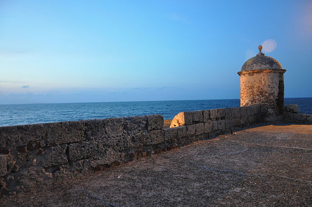
Cartagena de Indias was founded on 1 June 1533 by Spanish commander Pedro de Heredia, in the former location of the indigenous Caribbean Calamarí village. The town was named after Cartagena, Spain, where most of Heredia's sailors came from. Initially, life in the city was bucolic, with fewer than 2000 inhabitants and only one church. A few months after the disaster of the invasion of Cote (see below), a fire destroyed the city and forced the creation of a firefighting squad, the first in the Americas. The dramatically increasing fame and wealth of the prosperous city turned it into an attractive plunder site for pirates and corsairs – French privateers licensed by their king. Just 30 years after its founding, the city was pillaged by the French nobleman Jean-François Roberval. The city then set about strengthening its defences and surrounding itself with walled compounds and castles.Martin Cote, a Basque from Biscay, attacked years later. Many pirates had plans to perpetrate similar schemes involving Cartagena, which became more and more interesting to them. In 1568, Sir John Hawkins of England tried to trick Gov. Martín de las Alas to go against Spanish law and open a foreign fair in the city to sell goods, planning to ravage the port afterwards. The governor declined and Hawkins besieged the city but failed to reduce it. In 1586, Sir Francis Drake, also of England, and nephew of Hawkins, came with a strong fleet and quickly took the city. The governor, Pedro Fernández de Busto, fled with the Archbishop to the neighboring town of Turbaco, and from there negotiated the costly ransom for the city: 107,000 Spanish Eight Reales of the time, or around 200 million in today's US dollars. Drake had destroyed one-quarter of the city, the developing Palace of the Township, and the recently finished cathedral. After this disaster, Spain poured millions every year into the city for its protection, beginning with Gov. Francisco de Murga's planning of the walls and forts; this practice was called "Situado". The magnitude of this subsidy is shown by comparison: between 1751 and 1810, the city received the sum of 20,912,677 Spanish reales, the equivalent of some 2 trillion dollars today. The city recovered quickly from the takeover by Drake and kept growing, and continued to attract attention from its opponents. The Raid on Cartagena in 1697 by Sir Bernard Desjean, Baron de Pointis and Jean Baptiste Ducasse was an all-out invasion that was politically motivated. There being no male successor to the Spanish Habsburg throne, King Louis XIV wanted his grandson Felipe V to assert the right of succession, and the taking of Cartagena de Indias could help significantly. A part of the 16- and 17-century fortress of San Felipe de Barajas Many crates of Spanish reales such as these were stored in Cartagena to be distributed throughout the Spanish empire The political purpose behind the invasion was somewhat undermined by Ducasse, the governor of Saint-Domingue – today's Haiti – who brought his soldiers with a plan to steal, but ended with pirates and thieves again destroying the city. Entry to the city was not easy because of the recently finished first stage of walls and forts, which slowed the invasion and made it costly. While Desjean only asked for 250,000 Spanish reales in ransom, Ducasse stayed a few months and dishonored the baron's promise to respect the churches and holy places, and left the inhabitants with nothing. The city had again lost everything. During the seventeenth century, the Spanish Crown paid for the services of prominent European military engineers to carry out the construction of the fortresses which are today Cartagena's most significant identitifying features. Engineering works took well over 208 years and ended with some eleven kilometres of walls surrounding the city, including the Castillo San Felipe de Barajas, es.wikipedia.org/wiki/Castillo_San_Felipe_de_Barajas, named in honor of Spain's King Philip IV. It was built during the governorship of Pedro Zapata de Mendoza, Marquis of Barajas and was constructed to repel land attacks, equipped with sentry boxes, buildings for food and weapons storage, and underground tunnels. When the defenses were finished in 1756, the city was considered impregnable. Legend has it that Charles III of Spain, while reviewing in Madrid the Spanish defense expenditures for Havana and Cartagena de Indias, looked through his spyglass and remarked "This is outrageous! For this price those castles should be seen from here!" [Wikipedia.org] |
| Date | |
| Source | The sea from Cartagena's fortresses built by the Spanish to defend it - Engineering works took well over 208 years and ended with some eleven kilometres of walls surrounding the city |
| Author | Jorge Láscar from Australia |
| Camera location | | View this and other nearby images on: OpenStreetMap |
|---|
Licensing
[edit]- You are free:
- to share – to copy, distribute and transmit the work
- to remix – to adapt the work
- Under the following conditions:
- attribution – You must give appropriate credit, provide a link to the license, and indicate if changes were made. You may do so in any reasonable manner, but not in any way that suggests the licensor endorses you or your use.
| This image was originally posted to Flickr by Jorge Lascar at https://www.flickr.com/photos/8721758@N06/4625657931. It was reviewed on 2 April 2014 by FlickreviewR and was confirmed to be licensed under the terms of the cc-by-2.0. |

.jpg&action=edit§ion=1)
.jpg¶ms=010.424398_N_-075.554369_E_globe:Earth_type:camera_source:Flickr_&language=en)
.jpg&action=edit§ion=2)
.jpg&action=edit&withJS=MediaWiki:Catcheck.js)
File history
Click on a date/time to view the file as it appeared at that time.
| Date/Time | Thumbnail | Dimensions | User | Comment | |
|---|---|---|---|---|---|
| current | 07:49, 2 April 2014 | | 3,216 × 2,136 (1.74 MB) | Russavia (talk | contribs) | Transferred from Flickr |
You cannot overwrite this file.
File usage on Commons
There are no pages that use this file.
.jpg&oldid=451229528)