Category:Maps of forests
Jump to navigation
Jump to search
Subcategories
This category has the following 6 subcategories, out of 6 total.
Media in category "Maps of forests"
The following 49 files are in this category, out of 49 total.
-
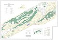 1983 Map of the north portion of the Jefferson National Forest in southwest Virginia.jpg 13,088 × 9,025; 15.17 MB
-
 1983 Map of the south portion of the Jefferson National Forest in southwest Virginia.jpg 13,192 × 9,100; 16.43 MB
-
 470376main1 globaltreecanopy-map-670.jpg 670 × 340; 113 KB
-
 470377main globaltreecanopy cutoutmap.jpg 7,888 × 3,440; 3.35 MB
-
 Above-ground biomass in forest per hectare, OWID.svg 850 × 600; 140 KB
-
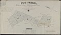 Amt Freren Forstrevier Freren Farbige Zeichnung von 1836 im Format 66 mal 115 Zentimeter.jpg 6,503 × 3,803; 1.39 MB
-
 Barrage vert.png 870 × 510; 628 KB
-
 BUSSACO 17.jpg 8,478 × 4,428; 12.51 MB
-
 CYII (1929 M) 09.jpg 3,100 × 4,019; 2.55 MB
-
 Czechoslovakia - Forest Cover Types - DPLA - 537a50563a37e1c1f09f980dd1d628bc.jpg 8,668 × 5,120; 4.16 MB
-
 Flii globe.png 1,657 × 832; 767 KB
-
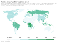 Forest area (% of land area), OWID.svg 850 × 600; 140 KB
-
 Forest area as share of land area, OWID.svg 850 × 600; 169 KB
-

-
 Forest area in km², OWID.svg 850 × 600; 141 KB
-
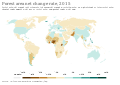 Forest area net change rate, OWID.svg 850 × 600; 141 KB
-
 Forest covert.jpg 9,895 × 4,288; 6.64 MB
-
 Forest distribution in Australia, 2018.png 1,141 × 801; 380 KB
-
 Forest in the world.JPG 897 × 485; 42 KB
-
 Forest map of Russia, from a 1902 book.jpg 2,032 × 1,523; 595 KB
-
 Forest-area-as-share-of-land-area.png 3,400 × 2,400; 813 KB
-
 Forest-area-net-change-rate.png 3,400 × 2,400; 771 KB
-
 Foret type TO.png 6,493 × 4,651; 5.16 MB
-
 Fovslet skov og svanemosen.jpg 2,129 × 1,571; 884 KB
-
 Global Forest Area.svg 792 × 612; 447 KB
-
 Global tree canopy map NASA.jpg 7,920 × 3,472; 3.67 MB
-
 Iflmap.png 1,048 × 620; 56 KB
-
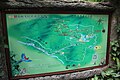
 Kakamega forest map.jpg 498 × 512; 56 KB
-
 LA JURISDICCIÓN (1915) 00.jpg 2,802 × 4,270; 4.65 MB
-
 Largest forests in Lithuania.png 1,461 × 1,080; 161 KB
-
 Lesistość w Europie.png 406 × 423; 15 KB
-
 Nadleśnictwo Drewnica mapa.jpg 2,988 × 5,312; 4.16 MB
-
 Percentage of land area of different European countries covered by Forest.pdf 4,260 × 3,581; 777 KB
-
 Plan general de la forest de Fontainebleau - André Desquinemare.jpg 11,934 × 9,894; 30.23 MB
-

-
 Proportion of forest area with a long-term management plan, OWID.svg 850 × 600; 139 KB
-

-
 Russia Percentage of Forest Cover.png 6,576 × 3,990; 1.67 MB
-
 Russland BV043569995.jpg 1,876 × 1,418; 448 KB
-
 Share-global-forest (OWID 1011).png 850 × 600; 93 KB
-
 Superficie Forestale assoluta nelle regioni italiane.png 2,480 × 4,076; 265 KB
-
 The Audubon annual bulletin (1916) (20355926151).jpg 2,553 × 4,143; 938 KB
-
 Tropical Forests 2000 by Major Ecological Domains.tif 3,508 × 2,480; 8.3 MB
-
 Tropical forests.tif 3,508 × 2,480; 8.3 MB
-
 Tropical tree density.tif 3,508 × 2,480; 8.3 MB
-
 World forest cover then and now.png 2,753 × 1,400; 186 KB
-
 World-Canopy.png 4,779 × 2,354; 3.11 MB
-
 Карта Янода.jpg 1,055 × 703; 312 KB
-
 Тайга и пасеки НПЦ "АПИЛАД".png 1,262 × 628; 39 KB


_09.jpg)


,_OWID.svg)


_00.jpg)


.png)

_(20355926151).jpg)


