Category:SVG labeled maps of administrative divisions of Saint Vincent and the Grenadines (location map scheme)
Jump to navigation
Jump to search


.svg)


_(Paris_zoom).svg)
.svg)
,_administrative_divisions_-_de_-_colored_(multizoom).svg)
_-_colored.svg)
.svg)
,_administrative_divisions_-_Nmbrs_(multizoom).svg)
,_administrative_divisions_-_de_-_colored.svg)
_-_de_-_colored.svg)

.svg)

.svg)

Media in category "SVG labeled maps of administrative divisions of Saint Vincent and the Grenadines (location map scheme)"
The following 7 files are in this category, out of 7 total.
-
 Saint Vincent and the Grenadines, administrative divisions - de - colored.svg 1,590 × 1,998; 371 KB
-
 Saint Vincent and the Grenadines, administrative divisions - de - monochrome.svg 1,590 × 1,998; 372 KB
-
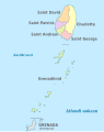 Saint Vincent and the Grenadines, administrative divisions - et - colored.svg 1,590 × 1,998; 398 KB
-
 Saint Vincent and the Grenadines, administrative divisions - mk - monochrome.svg 1,590 × 1,998; 454 KB
-
 Saint Vincent and the Grenadines, administrative divisions - Nmbrs - colored.svg 1,590 × 1,998; 371 KB
-
 Saint Vincent and the Grenadines, administrative divisions - Nmbrs - monochrome.svg 1,590 × 1,998; 372 KB
-
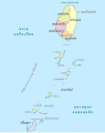 Saint Vincent and the Grenadines, administrative divisions - th - colored.svg 1,590 × 1,998; 537 KB


Categories:
- SVG labeled maps of administrative divisions of countries of North America (location map scheme)
- SVG labeled maps of administrative divisions of countries of the Caribbean (location map scheme)
- SVG maps of Saint Vincent and the Grenadines
- Political maps of Saint Vincent and the Grenadines
- Subdivisions of Saint Vincent and the Grenadines