Category:SVG labeled maps of administrative divisions of Syria (location map scheme)
Jump to navigation
Jump to search


.svg)


_(Paris_zoom).svg)
.svg)
,_administrative_divisions_-_de_-_colored_(multizoom).svg)
_-_colored.svg)
.svg)
,_administrative_divisions_-_Nmbrs_(multizoom).svg)
,_administrative_divisions_-_de_-_colored.svg)
_-_de_-_colored.svg)

.svg)

.svg)
Media in category "SVG labeled maps of administrative divisions of Syria (location map scheme)"
The following 15 files are in this category, out of 15 total.
-
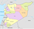
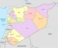 Syria (+Golan), administrative divisions - de - colored.svg 922 × 762; 308 KB
-
 Syria (+Golan), administrative divisions - de - monochrome.svg 922 × 762; 309 KB
-
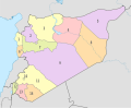 Syria (+Golan), administrative divisions - Nmbrs - colored.svg 922 × 762; 309 KB
-
 Syria (+Golan), administrative divisions - Nmbrs - monochrome.svg 922 × 762; 309 KB
-
 Syria (-Golan), administrative divisions - de - colored.svg 922 × 762; 308 KB
-
 Syria (-Golan), administrative divisions - de - monochrome.svg 922 × 762; 309 KB
-
 Syria (-Golan), administrative divisions - Nmbrs - colored.svg 922 × 762; 309 KB
-
 Syria (-Golan), administrative divisions - Nmbrs - monochrome.svg 922 × 762; 309 KB
-
 Syria 2016, administrative divisions - de - colored.svg 921 × 761; 307 KB
-
 Syria 2016, administrative divisions - th - colored.svg 921 × 761; 419 KB
-
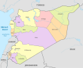
 Syria, administrative divisions - de - colored.svg 922 × 762; 311 KB
-
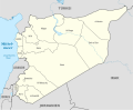
 Syria, administrative divisions - de - monochrome.svg 922 × 762; 311 KB
-
 Syria, administrative divisions - et - colored.svg 921 × 761; 406 KB
-
 Syria, administrative divisions - Nmbrs - colored.svg 922 × 762; 311 KB
-
 Syria, administrative divisions - Nmbrs - monochrome.svg 922 × 762; 311 KB
,_administrative_divisions_-_de_-_colored.svg)
,_administrative_divisions_-_de_-_monochrome.svg)
,_administrative_divisions_-_Nmbrs_-_colored.svg)
,_administrative_divisions_-_Nmbrs_-_monochrome.svg)
,_administrative_divisions_-_de_-_colored.svg)
,_administrative_divisions_-_de_-_monochrome.svg)
,_administrative_divisions_-_Nmbrs_-_colored.svg)
,_administrative_divisions_-_Nmbrs_-_monochrome.svg)


